Dave Amos doesn't just report on a traffic change; he documents the quiet erasure of a street that once defined American car culture. His most striking observation isn't that Broadway is becoming pedestrian-friendly, but that the city's most famous thoroughfare is effectively vanishing from the map, replaced by a patchwork of plazas and bike lanes that defy the rigid grid of Manhattan. For busy urbanists watching cities struggle with congestion and climate, this piece offers a rare, ground-level look at a transformation that proves car-centric planning isn't inevitable.
The Vanishing Street
Amos begins by leveraging the familiar interface of Google Maps to reveal a visual paradox. He notes that while Broadway is a "broad boulevard slicing through the Upper West Side," it shrinks to a single lane or disappears entirely as it hits Midtown. "Looking at the overall Google Maps view, it almost seems to disappear from the map entirely," he writes, a claim that immediately grabs the reader's attention by challenging their mental map of New York. This isn't a disappearance of asphalt, but a shift in priority. The author argues that the street has traded fast-moving traffic for "pedestrian spaces, outdoor seating, bike lanes, plazas, and more." The evidence here is compelling because it relies on the reader's own visual literacy; we all know what a car lane looks like, and Amos shows us where it used to be.
"One of the greatest streets in the world vanishing from the map."
Tactical Urbanism in Action
The core of Amos's argument rests on the concept of "tactical urbanism," a strategy of using low-cost, temporary interventions to test public space designs before making them permanent. He describes how the city deployed "obstacles like these boulders to separate cars from people" and used paint to "liven up the ground surface and again indicate that this is a space for people and not cars." This approach is effective because it lowers the political risk of change; if a plaza fails, it can be removed without a massive construction budget. Amos observes that successful temporary measures, like movable furniture, are eventually replaced with permanent pavers and planters. This evolution from temporary to permanent is the story of Times Square, which he notes now features the "nicest, most permanent materials" along the corridor.
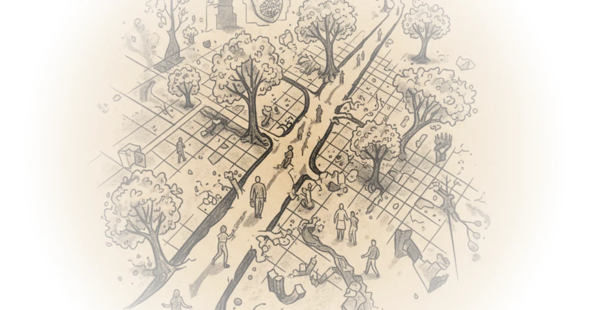
Critics might argue that this block-by-block experimentation leads to a disjointed experience for pedestrians and cyclists, a point Amos himself acknowledges. He admits there is "a lot of inconsistency in the configuration of the spaces," noting that bike lanes sometimes appear in the middle of the street and sometimes vanish entirely. However, he frames this not as a failure, but as a deliberate choice to treat Broadway as a series of local streets rather than a unified boulevard.
The Neighborhood Model vs. The Haussmann Standard
Amos draws a fascinating historical contrast between New York's approach and the "Paris Boulevard model" of Baron Haussmann, who tore down neighborhoods to create uniform, grand avenues. "The Houseman model only really works when you have a dictator supporting your efforts and you're cool with displacing like a ton of people," Amos quips, highlighting the democratic, albeit messy, nature of New York's planning. Instead of a top-down mandate, the city worked with local groups like the "Times Square Alliance" and "Garment District Alliance" to tailor each section to neighborhood needs. This results in a corridor that "morphs and changes configuration based on neighborhood needs and wants," creating a street that feels more local than tourist-oriented.
"If Broadway, a street named for how wide it is and used to be called Automobile Row, can now effectively be evicting all cars from its busiest, most culturally significant stretch, then some real change must be happening out there."
This framing is powerful because it connects a specific infrastructure project to a broader narrative of urban progress. Amos traces the street's history from a Westquese trail to "Automobile Row," a hub for car showrooms in the early 20th century, to its current state. The shift from a street built for cars to one built for people is presented as a symbolic victory. However, the piece does gloss over the friction this causes for long-time residents who may miss the predictability of a unified street design. The inconsistency Amos praises for its local responsiveness can also be frustrating for anyone trying to navigate the corridor efficiently.
The Data Behind the Design
The commentary takes a sharp turn into the mechanics of how these decisions are made, crediting the "congestion pricing program" for reducing private vehicles and creating a better environment for pedestrians. Amos highlights the role of robust data in this process, specifically mentioning tools like TomTom Move that allow planners to analyze traffic at the intersection level. He describes how "junction analytics" can monitor turn ratios and delays, providing the evidence needed to justify removing lanes. While this section reads like a sponsorship integration, it underscores a critical point: modern urban planning is no longer just about intuition; it is driven by granular, real-time data that proves pedestrianization works.
"The gradual process of pedestrianization to me is symbolic of progress in our cities."
Bottom Line
Dave Amos delivers a persuasive case that Broadway's transformation is a triumph of adaptive, community-driven planning over rigid, car-centric dogma. The piece's greatest strength is its ability to visualize the invisible shift in street priority, though it occasionally struggles to reconcile the benefits of local customization with the need for a cohesive corridor experience. As cities worldwide grapple with the legacy of the automobile, the Broadway Vision Plan offers a hopeful, if messy, blueprint for reclaiming public space.